Tocht Paardrijden La Tieule - Boucle  La Canourgue/ La Tieule / Mas Rouch  - Photo

Boucle La Canourgue/ La Tieule / Mas Rouch

 Lozère Cheval
Lozère Cheval

Gebruiker

© OpenStreetMap contributors
Lengte
Lengte
66 km
Max. hoogte
Max. hoogte
980 m
Positief hoogteverschil
1858 m
Km-Effort
Km-Effort  
91 km
Min. hoogte
Min. hoogte
544 m
Negatief hoogteverschil
1861 m
Boucle
Boucle
Ja
Datum van aanmaak :
2020-02-09 15:35:03.809
Laatste wijziging :
2021-10-29 13:35:23.813

(0 Bericht)

Paardrijden
Paardrijden
--
Moeilijkheid : Heel gemakkelijk

Scan deze QR-code om de tocht te openen in de SityTrail-applicatie

Gratisgps-wandelapplicatie

Logo SityTrail SityTrail

IGN / Geografische instituten

SityTrail uit de App Store downloaden SityTrail uit Google Play downloaden

Logo SityTrail SityTrail World

De wereld gaat voor u open

SityTrail uit de App Store downloaden SityTrail uit Google Play downloaden SityTrail op Huawei AppGallery downloaden

Over ons

Tocht Paardrijden van 66 km beschikbaar op Occitanië, Lozère, La Tieule. Deze tocht wordt voorgesteld door Lozère Cheval.

Beschrijving

Rajouter les autres fusions pour circuit complet

Hoogteprofiel

POI's

POI La Tieule - Les Ecuries de Sauveterre - Photo
Lozère Cheval
POI Banassac-Canilhac - Le Cascadou - Photo
Lozère Cheval
BANASSAC-CANILHAC 
POI Mas-Saint-Chély - Gite de la Carbadelle - Photo
Lozère Cheval
MAS-SAINT-CHÉLY 
POI Massegros Causses Gorges - Camping Cassaduc Mr. Roujon - Photo
Lozère Cheval
MASSEGROS CAUSSES GORGES 

Plaatsbepaling

Land:
France
Regio :
Occitanië
Departement/Provincie :
Lozère
Gemeente :
La Tieule
Locatie:
Unknown
Vertrek:(UTM)
512426 ; 4914569 (31T) N.

Wandeltochten in de omgeving

Tocht Stappen La Canourgue - Dessus la canourgue - Photo
Stappen
peillo

Stappen

Moeilijk
La Canourgue, Occitanië, Lozère, France
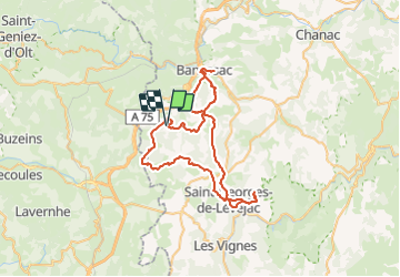
9,1 km | 14,4 km-effort
3h 48min
Neen
Tocht Stappen Saint-Saturnin - Vers l'antenne de La Canourgue - Photo
Stappen
Alain-49

Stappen

Gemakkelijk
Saint-Saturnin, Occitanië, Lozère, France
6,9 km | 8,8 km-effort
1h 42min
Ja
Tocht Paardrijden La Tieule - La Tieule - Etoile par Le Maynard - Photo
Paardrijden
Lozère Cheval

Paardrijden

Moeilijk
La Tieule, Occitanië, Lozère, France
27 km | 37 km-effort
4h 53min
Ja
Tocht Paardrijden La Tieule - Etoile La Tieule par Rouge Parets - Photo
Paardrijden
Lozère Cheval

Paardrijden

Moeilijk
La Tieule, Occitanië, Lozère, France
26 km | 36 km-effort
4h 45min
Ja
Tocht Paardrijden La Tieule - Etoile de Coustaraços ( La Tieule par Meynard et Pertuzades) - Photo
Paardrijden
Lozère Cheval

Paardrijden

Zeer moeilijk
La Tieule, Occitanië, Lozère, France
29 km | 42 km-effort
5h 33min
Ja
Tocht Stappen La Tieule - Chemin de St Guilhem - La Tieule - Saint Georges de Lévéjac - Photo
Stappen
GUIDE
Kargil

Stappen

Zeer moeilijk
La Tieule, Occitanië, Lozère, France
21 km | 28 km-effort
5h 56min
Neen
Tocht Paardrijden La Tieule - Grande Boucle Tieule/Canourgue/Champerboux/StEnimie/MasRouch/Tieule - Photo
Paardrijden
Lozère Cheval

Paardrijden

Zeer moeilijk
La Tieule, Occitanië, Lozère, France
91 km | 123 km-effort
15h 4min
Ja
Tocht Stappen Campagnac - Campagnac - Photo
Stappen
denis48230

Stappen

Heel gemakkelijk
Campagnac, Occitanië, Aveyron, France
14 km | 17,9 km-effort
5h 52min
Ja
Tocht Stappen La Canourgue - Roqueprins La Canourgue - Photo
Stappen
micmouren

Stappen

Gemakkelijk
La Canourgue, Occitanië, Lozère, France
4,1 km | 7,9 km-effort
54min
Ja


Sluiten
Mijn abonnementen